
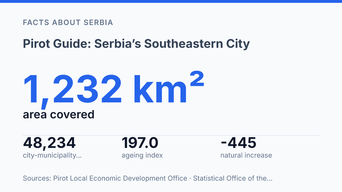
Pirot is bigger on the map than its population suggests: 1,232 km², Serbia’s third-largest city area, spread across 71 inhabited places beyond the center. That scale changes how you should read the city.
It isn’t just a dot in southeastern Serbia. It’s a district seat with roads, offices, schools, markets, and decisions pulling rural life toward one urban core.
The contrast is sharp. The city gained formal city status in 2016, yet its population is shrinking and ageing fast. From the Free Zone, Sofia sits 87 km away.
The demographic story points inward: fewer children, more older residents. A built-up area that doesn’t match the official settlement line.
This guide looks at location, census figures, district power. The first thing visitors should understand. In my honest opinion, the smart way to see the city is not as a quiet provincial stop, but as a wide regional system with a surprisingly intimate center.
Where Pirot sits in southeastern Serbia
Serbia’s southeast narrows fast here: the city sits closer to Sofia than many readers expect, with Niš 76 km away and the Bulgarian capital 87 km away, according to Serbia’s Free Zones Administration.
That position gives the place a borderland logic without making it feel remote. Roads, trade routes, and cross-border movement all shape how the city functions. So does administration: Pirot is the administrative center of Pirot District, the point where district-level services and local identity meet.
Numbers sharpen the map. According to the 2022 census, the official urban area had 34,942 residents, compared with 49,601 in the wider city administrative area. That contrast is the first thing to understand before reading any local statistic.
But the larger figure can mislead if you picture one compact urban place. The administrative area covers far more than the central streets most visitors would recognize. The local economic development office puts the territory at 1,232 km², with 71 inhabited places outside the city center.
That’s the tension built into its geography. The city is smaller than its administrative reach suggests. That wider reach is part of why it matters. In my view, this gap is the detail that keeps local population figures from being misunderstood.
What the census figures say about the city
The city looks noticeably bigger in official tables than it feels when you’re standing in the built-up center. That gap comes from how the census draws its boxes, not from any trick in the figures.
In the 2022 census, the urban settlement count refers to the compact city itself. The wider local-government count includes the central settlement plus surrounding villages and smaller inhabited places under the same administration. According to the Statistical Office of the Republic of Serbia, those are two different measurements of the same place: one shows the urban core, the other shows the full administrative unit.
The plain comparison matters most. The broader area has 14,659 more residents than the urban core. A large share of the population lives outside the tight city footprint.
That doesn’t make the center unimportant. It shows how much local life is spread across settlements that still depend on the main city for services, jobs, schools, and paperwork.
There’s a useful complication here. World Bank data from 2023 also gives a count for the continuous built-up settlement, placing it 4,258 people above the official urban settlement figure. That suggests everyday urban life spills past the formal line on the map, but still doesn’t cover the full administrative population.
In my honest opinion, this is the number readers should keep in mind: the administrative city is a service area, not just a dense urban block. If you read only the larger total, you may picture a bigger city than the one you actually encounter on the ground.
Why the district seat matters for local life
A resident may travel farther for a property record than for groceries, and that’s where district-seat status becomes visible. The city isn’t just another settlement in the district map. It is where regional paperwork, public offices, and many higher-level services concentrate.
The Local Economic Development Office describes the city as the economic, cultural, and administrative seat of Pirot District, notes its city status from 2016, and gives a population density of about 44 inhabitants per km². That combination matters. A low-density area needs a clear center, or routine tasks become slow and expensive for people outside the urban core.
District-center status shows up in practical ways. Residents come in for court-related matters, cadastral records, tax issues, health administration, school procedures, social welfare services, and employment-office appointments.
Not every office serves every village from a local desk. Many functions sit in the city, so travel patterns follow administration as much as shopping or family ties.
Take a simple land-inheritance case. A family from a smaller settlement may need a death certificate, property documentation, a notary appointment, and contact with a public office before anything moves forward.
If those steps sit in different localities, the process becomes a burden. When most of them are clustered in the district seat, one trip can solve what would otherwise take several.
That gives the city weight beyond its population. It doesn’t turn it into a large urban center. In my humble opinion, this is the detail that makes smaller Serbian cities easy to misread. Their influence comes less from skyline or scale and more from the fact that everyone around them needs them at certain moments.
The tradeoff is clear. Centralizing services makes administration easier to staff and manage. It also means people in outlying settlements depend on transport, opening hours.
The patience required for public paperwork. For local life, that dependency is not abstract. It shapes errands, bus trips, workdays, and how connected the district feels in daily practice.
What visitors and readers should remember first
The useful story here isn’t size alone. It’s the mismatch between population, function, and regional importance.
This southeastern Serbian city is modest by headcount. It carries more weight than a quick glance at the map suggests.
The 2022 census gives the cleanest reminder: 34,942 people lived in the urban area, while 49,601 lived across the wider city administrative area. That gap matters. It shows a place that can’t be read only as its compact urban core, even if that core is what most visitors notice first.
Its role in Pirot District sharpens the point. The city serves as the district’s administrative center, so local life gathers around it in ways that outstrip its population. In my view, that’s the detail to remember: this is not a large Serbian city pretending to be regional. It’s a smaller southeastern center whose importance comes from what it does for the surrounding area.
For visitors, that means the first read should be practical, not romantic. Look at the city as both a lived urban place and a service center for a broader territory.
The numbers tell one part of the story. The district role explains why the place matters.
What the map can’t tell you from a distance
The next question isn’t whether Pirot’s future will look smaller. It is what kind of regional center it chooses to be as 2024 records –445 natural increase and Serbia keeps pulling people toward larger labor markets.
For you, that changes how to read the place. Don’t stop at the old center or a kilim pattern in a shop window.
Look at the bus routes, schools, clinics, district offices, empty homes. The villages tied to them.
In my humble opinion, the city makes most sense when you treat beauty and decline as part of the same story. A place can lose population and still carry a region. That tension is the point.
Frequently Asked Questions
Q: Where is Pirot located in Serbia?
A: Pirot sits in southeastern Serbia and serves as the administrative center of the Pirot District. That makes it more than a stop on the map. It’s the main local hub for the area. 2022 census figures confirm its current size and role. Pirot anchors a wider district, not just the urban core. 49,601 people live in the city’s administrative area.
Q: How many people live in Pirot?
A: The urban area has 34,942 residents, based on the 2022 census. The full administrative area is bigger, with 49,601 inhabitants. That gap matters, because the city’s reach goes beyond the center itself.
Q: Is Pirot the same as the Pirot District?
A: No. Pirot is the city and the administrative center of the Pirot District. The district itself covers a wider area. That distinction trips people up. It matters when you’re looking at population, services, or local administration. Pirot is the center. The district is the larger unit. 2022 gives the latest census picture. 34,942 people live in the urban area.
Q: Why do people search for Pirot as a travel destination?
A: Because it’s a real city with a clear regional role, not just a pin on a route. Travelers want context, and Pirot gives them a southeastern Serbian base with an identifiable urban center and a wider surrounding area. In my view, that’s what makes it easier to understand than a lot of smaller towns.
Q: What population should I use when writing about Pirot?
A: Use the number that matches the area you mean. For the city proper, use 34,942. For the entire administrative area, use 49,601. That difference is small on paper. It changes the story fast.